MDZ003
Winter Storm Warning issued December 16 at 5:16AM EST until December 17 at 4:00AM EST by NWS
...
WINTER STORM WARNING REMAINS IN EFFECT UNTIL 4 AM EST THURSDAY...
 * WHAT...
Heavy mixed precipitation expected. Total snow and sleet accumulations of 6-12 inches to the
east of the Blue Ridge. Snow accumulations of 12-18 inches from the I-81 corridor
westward, as well as near the Mason-Dixon Line. Ice
Winter Storm Warning
****************
...WINTER STORM WARNING REMAINS IN EFFECT UNTIL 4 AM EST
THURSDAY...
* WHAT...Heavy mixed precipitation expected. Total snow and
sleet accumulations of 6-12 inches to the east of the Blue
Ridge. Snow accumulations of 12-18 inches from the I-81
corridor westward, as well as near the Mason-Dixon Line. Ice
accumulation of around a tenth of an inch near the Blue Ridge
Mountains.
* WHERE...Portions of north central and western Maryland,
northern and northwest Virginia and eastern and panhandle West
Virginia.
* WHEN...Until 4 AM EST Thursday. Snow will overspread the area
between 9 and 11 AM. Snow will mix with sleet and freezing rain
during the afternoon and evening hours near the Blue Ridge
mountains. The heaviest snow is most likely during the late
afternoon and evening hours.
* IMPACTS...Travel could be very difficult to impossible. The
hazardous conditions could impact the morning or evening
commute.
* ADDITIONAL DETAILS...Visibility will be reduced below one-
quarter mile at times in snow.
If you must travel, keep an extra flashlight, food, and water in
your vehicle in case of an emergency.
When venturing outside, watch your first few steps taken on
steps, sidewalks, and driveways, which could be icy and slippery,
increasing your risk of a fall and injury.

| Weather-4-Smithsburg Data | |||
|---|---|---|---|
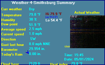
| LAST READING AT TIME: 14:55 DATE: December 16 2020, time of next update: 15:00 | |||
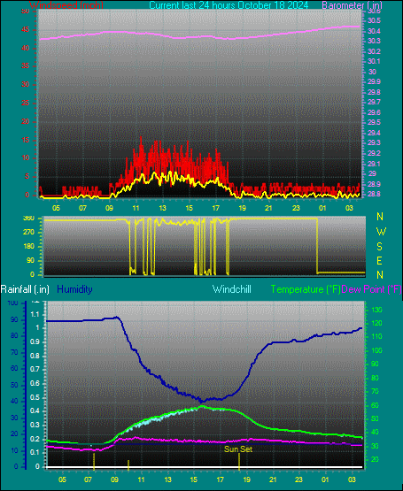
| Current Weather | Dry | Current Temperature | 28.0°F (-2.2°C), Apparent temp 22.3°F |
| Maximum Temperature (since midnight) | 31.1°F at: 00:48 | Minimum Temperature (since midnight) | 27.1°F at: 13:31 |
| Average windspeed (ten minute) | 4.9 mph | Wind Direction (ten minute) | ENE (76°) |
| Windchill Temperature | 22.8°F | Maximum Gust (last hour) | 16.1 mph at: 13:54 |
| Maximum Gust (since midnight) | 25.3 mph at: 03:39 | Maximum 1 minute average (since midnight) | 18.4 mph at: 04:56 |
| Rainfall (last hour) | 0.00 in. (0.0 mm) | Rainfall (since midnight) | 0.00 in. (0.0 mm) --- |
| Rainfall This month | 1.35 in. (34.3 mm) | Rainfall To date this year | 31.40 in. (797.6 mm) |
| Maximum rain per minute (last hour) | 0.00 in/min | Maximum rain per hour (last 6 hours) | 0.00 in/hour |
| Yesterdays rainfall | 0.00 in | DewPoint | 25.2°F (Wet Bulb :27.1°F ) |
| Humidity | 89 %, Humidex 22.6°F | Barometer corrected to msl | 30.046 in. (1017.5 hPa) |
| Pressure change | -0.05 in. (last hour) | Trend (last hour) | FALLING |
| Pressure change (last 12 hours) | -0.31 in | Pressure change (last 6 hours) | -0.23 in |
| Current Indoor Temp. 72.3°F | |||
| Current Indoor Hum. 37% | |||

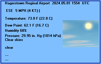
HAGERSTOWN REGIONAL AIRPORT, MD, United States (KHGR) 39-42N 077-44W 224M
Dec 16, 2020 - 01:53 PM EST / 2020.12.16 1853 UTC
Wind: from the NNE (030 degrees) at 12 MPH (10 KT):0
Visibility: 1/4 mile(s):0
Sky conditions: obscured
Weather: snow; freezing fog
Precipitation last hour: 0.07 inches
Temperature: 27.0 F (-2.8 C)
Windchill: 15 F (-9 C):1
Dew Point: 24.1 F (-4.4 C)
Relative Humidity: 88%
Pressure (altimeter): 30.08 in. Hg (1018 hPa)
ob: KHGR 161853Z 03010KT 1/4SM SN FZFG VV010 M03/M04 A3008 RMK AO2 SLP204 P0007 T10281044
cycle: 19
ANNAPOLIS US NAVAL ACADEMY, MD, United States (KNAK) 38-59N 76-29W 11M
Dec 16, 2020 - 01:54 PM EST / 2020.12.16 1854 UTC
Wind: from the NE (040 degrees) at 13 MPH (11 KT) gusting to 22 MPH (19 KT):0
Visibility: 4 mile(s):0
Sky conditions: overcast
Weather: rain; mist
Precipitation last hour: 0.08 inches
Temperature: 34.0 F (1.1 C)
Windchill: 24 F (-4 C):1
Dew Point: 34.0 F (1.1 C)
Relative Humidity: 100%
Pressure (altimeter): 30.07 in. Hg (1018 hPa)
ob: KNAK 161854Z AUTO 04011G19KT 4SM RA BR SCT013 OVC024 01/01 A3007 RMK AO2 SLP184 P0008 T00110011
cycle: 19
Use the RELOAD facility on your browser to retrieve the latest data.
|

|